
Benmore Botanic Garden (Argyllshire)


|
Benmore Botanic Garden (Argyllshire) |
|
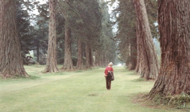 Benmore Giant Sequoia Avenue - 1980 |
| Thanks to Iris for the above photograph taken in 1980 of the Sequoia Avenue at Benmore Botanic Garden. Benmore is set within the Loch Lomond & The Trossachs National Park and the Argyll Forest Park, seven miles north of Dunoon on the Cowal Peninsula. |
 |
| Thanks to Tim for allowing us to use the above picture from a page about Benmore Botanic Garden on his web site about Giant Sequoias in Belgium and the Netherlands. |
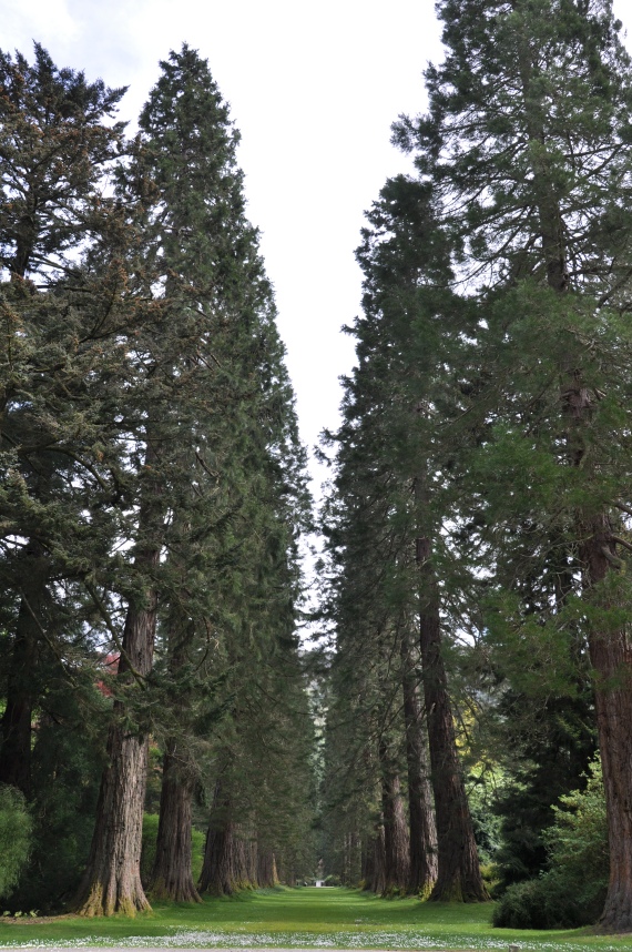
 Benmore Giant Sequoia Avenue - July 2007 |
| Thanks also to Tam for his contributions to this page. He kindly explained the positioning of the trees. "From the visitor centre (which has a lovely cafe) there are 11 Sequoias before you reach the bridge over the river, 9 of which form the beginning of the avenue. Once over the bridge the avenue of Giant Sequoias stretch into the distance there are 40 of them on this side. No 21 along was planted in 1995 possibly as a replacement for a redwood trunk lying off to one side." |
 |
 |
 |
| Giant Redwood *No.21 | Giant Redwood on lawn - July 2007 | Giant Redwood |
| "At the end of the avenue veering of to the path on the left takes you to a large house, which I believe is a training centre for botany students. The area in front of the house is a lawn with a few sequoias. There is another large one along one of the many paths standing on its own (single sequoia photo) and another two just outside the perimeter fence." | ||
 |
 |
 |
| Giant Redwood 12m tall | The Bridge | Dawn Redwood - July 2007 |
| "Notice the knobs (sequoia cones?) on the bridge in the picture showing the bridge over to the avenue. The picture of a Dawn Redwood in the grounds of Benmore Botanic Garden shows the only one of its type I could see." | ||
| Common Names and Latin Name | No. | Latitude and Longitude | OS National Grid | Elevation (above sea-level) |
Height | Girth | Date Measured | |
| WGS84 | OSGB36 | |||||||
| Giant Redwood Sequoiadendron giganteum | 1 | N56.02690 W4.98097 | N56.02700 W4.97980 | NS 14336 85566 | 104ft (31.71m) | -- | -- | -- |
| 2 | N56.02688 W4.98119 | N56.02698 W4.98002 | NS 14322 85564 | 105ft (32.01m) | -- | -- | -- | |
| 3 | N56.02684 W4.98139 | N56.02694 W4.98022 | NS 14309 85560 | 103ft (31.40m) | -- | -- | -- | |
| 4 | N56.02684 W4.98158 | N56.02694 W4.98041 | NS 14297 85561 | 99ft (30.18m) | -- | -- | -- | |
| 5 | N56.02681 W4.98174 | N56.02691 W4.98057 | NS 14287 85558 | 95ft (28.96m) | -- | -- | -- | |
| 6 | N56.02676 W4.98255 | N56.02686 W4.98138 | NS 14237 85554 | 60ft (18.29m) | -- | -- | -- | |
| 7 | N56.02674 W4.98269 | N56.02684 W4.98152 | NS 14228 85552 | 60ft (18.29m) | -- | -- | -- | |
| 8 | N56.02671 W4.98288 | N56.02681 W4.98171 | NS 14216 85550 | 62ft (18.90m) | -- | -- | -- | |
| 9 | N56.02671 W4.98310 | N56.02681 W4.98193 | NS 14202 85550 | 57ft (17.38m) | -- | -- | -- | |
| 10 | N56.02670 W4.98333 | N56.02680 W4.98216 | NS 14188 85550 | 56ft (17.07m) | -- | -- | -- | |
| 11 | N56.02666 W4.98347 | N56.02676 W4.98230 | NS 14179 85546 | 71ft (21.65m) | -- | -- | -- | |
| 12 | N56.02665 W4.98369 | N56.02675 W4.98252 | NS 14165 85545 | 74ft (22.56m) | -- | -- | -- | |
| 13 | N56.02665 W4.98392 | N56.02675 W4.98275 | NS 14151 85546 | 77ft (23.48m) | -- | -- | -- | |
| 14 | N56.02664 W4.98413 | N56.02674 W4.98296 | NS 14138 85545 | 83ft (25.30m) | -- | -- | -- | |
| 15 | N56.02662 W4.98430 | N56.02672 W4.98313 | NS 14127 85543 | 78ft (23.78m) | -- | -- | *Tam's No. 21 | |
| 16 | N56.02660 W4.98455 | N56.02670 W4.98338 | NS 14111 85542 | 80ft (24.39m) | -- | -- | -- | |
| 17 | N56.02656 W4.98467 | N56.02666 W4.98350 | NS 14104 85538 | 77ft (23.48m) | -- | -- | -- | |
| 18 | N56.02655 W4.98489 | N56.02665 W4.98372 | NS 14090 85537 | 75ft (22.87m) | -- | -- | -- | |
| 19 | N56.02653 W4.98508 | N56.02663 W4.98391 | NS 14078 85536 | 75ft (22.87m) | -- | -- | -- | |
| 20 | N56.02652 W4.98531 | N56.02662 W4.98414 | NS 14064 85535 | 82ft (25.00m) | -- | -- | -- | |
| 21 | N56.02651 W4.98552 | N56.02661 W4.98435 | NS 14050 85534 | 86ft (26.22m) | -- | -- | -- | |
| 22 | N56.02648 W4.98568 | N56.02658 W4.98451 | NS 14040 85532 | 89ft (27.13m) | -- | 6.58m | May 2009 | |
| 23 | N56.02645 W4.98589 | N56.02655 W4.98472 | NS 14027 85529 | 90ft (27.44m) | -- | -- | -- | |
| 24 | N56.02644 W4.98606 | N56.02654 W4.98489 | NS 14016 85528 | 90ft (27.44m) | -- | -- | -- | |
| 25 | N56.02642 W4.98642 | N56.02652 W4.98525 | NS 13994 85527 | 87ft (26.52m) | 39m | 5.05m | May 2009 | |
| 26 | N56.02654 W4.98633 | N56.02664 W4.98516 | NS 14000 85540 | 76ft (23.17m) | 39.8m | 5.5m | May 2009 | |
| 27 | N56.02652 W4.98615 | N56.02662 W4.98498 | NS 14011 85537 | 34ft (10.37m) | -- | 6.18m | May 2009 | |
| 28 | N56.02655 W4.98596 | N56.02665 W4.98479 | NS 14023 85540 | 44ft (13.41m) | 48.4m | 5.49m | May 2009 | |
| 29 | N56.02655 W4.98578 | N56.02665 W4.98461 | NS 14034 85540 | 49ft (14.94m) | -- | -- | -- | |
| 30 | N56.02660 W4.98558 | N56.02670 W4.98441 | NS 14047 85545 | 49ft (14.94m) | -- | -- | -- | |
| 31 | N56.02663 W4.98540 | N56.02673 W4.98423 | NS 14058 85548 | 45ft (13.72m) | -- | -- | -- | |
| 32 | N56.02663 W4.98518 | N56.02673 W4.98401 | NS 14072 85547 | 44ft (13.41m) | -- | -- | -- | |
| 33 | N56.02663 W4.98497 | N56.02673 W4.98380 | NS 14085 85546 | 47ft (14.33m) | -- | -- | -- | |
| 34 | N56.02664 W4.98479 | N56.02674 W4.98362 | NS 14096 85547 | 49ft (14.94m) | -- | -- | -- | |
| 35 | N56.02668 W4.98458 | N56.02678 W4.98341 | NS 14110 85551 | 31ft (09.45m) | -- | -- | -- | |
| 36 | N56.02671 W4.98440 | N56.02681 W4.98323 | NS 14121 85554 | 41ft (12.50m) | -- | -- | -- | |
| 37 | N56.02669 W4.98424 | N56.02679 W4.98307 | NS 14131 85551 | 45ft (13.72m) | -- | 5.68m | May 2009 | |
| 38 | N56.02674 W4.98402 | N56.02684 W4.98285 | NS 14145 85556 | 53ft (16.16m) | -- | -- | -- | |
| 39 | N56.02674 W4.98382 | N56.02684 W4.98265 | NS 14157 85556 | 49ft (14.94m) | -- | 6.8m | May 2009 | |
| 40 | N56.02672 W4.98360 | N56.02682 W4.98243 | NS 14171 85553 | 39ft (11.89m) | -- | -- | -- | |
| 41 | N56.02678 W4.98347 | N56.02688 W4.98230 | NS 14179 85559 | 35ft (10.67m) | -- | 6.28m | May 2009 | |
| 42 | N56.02678 W4.98328 | N56.02688 W4.98211 | NS 14191 85558 | 30ft (09.15m) | -- | -- | -- | |
| 43 | N56.02682 W4.98300 | N56.02692 W4.98183 | NS 14209 85562 | 29ft (08.84m) | -- | -- | -- | |
| 44 | N56.02682 W4.98285 | N56.02692 W4.98168 | NS 14218 85562 | 29ft (08.84m) | -- | -- | -- | |
| 45 | N56.02688 W4.98265 | N56.02698 W4.98148 | NS 14231 85568 | 32ft (09.76m) | -- | -- | -- | |
| 46 | N56.02697 W4.98178 | N56.02707 W4.98061 | NS 14286 85576 | 73ft (22.26m) | -- | -- | -- | |
| 47 | N56.02700 W4.98160 | N56.02710 W4.98043 | NS 14297 85578 | 75ft (22.87m) | -- | -- | -- | |
| 48 | N56.02702 W4.98140 | N56.02712 W4.98023 | NS 14310 85580 | 71ft (21.65m) | -- | -- | -- | |
| 49 | N56.02702 W4.98124 | N56.02712 W4.98007 | NS 14319 85580 | 71ft (21.65m) | -- | -- | -- | |
| Giant Redwood Sequoiadendron giganteum | 50 | N56.02480 W4.98836 | N56.02490 W4.98719 | NS 13865 85352 | 52ft (15.85m) | 21.1m | -- | May 2009 |
| 51 | N56.02509 W4.98703 | N56.02519 W4.98586 | NS 13949 85381 | 43ft (13.11m) | 33.5m | 8.2m | May 2009 has 8 children | |
| 52 | N56.02525 W4.98736 | N56.02535 W4.98619 | NS 13930 85399 | 32ft (09.76m) | 36.5m | 5.6m | May 2009 | |
| Coast Redwood Sequoia sempervirens | 53 | N56.02524 W4.98971 | N56.02534 W4.98854 | NS 13783 85404 | 119ft (36.28m) | 42.6m | 5.57m | May 2009 |
| 54 | N56.02515 W4.98990 | N56.02525 W4.98873 | NS 13771 85395 | 134ft (40.85m) | -- | -- | -- | |
| Giant Redwood Sequoiadendron giganteum | 55 | N56.02593 W4.98856 | N56.02603 W4.98739 | NS 13858 85478 | 117ft (35.67m) | 47.22m | 6.06m | May 2009 |
| Coast Redwood Sequoia sempervirens | 56 | N56.02601 W4.98751 | N56.02611 W4.98634 | NS 13924 85484 | 86ft (26.22m) | -- | 5.34m | May 2009 |
| Dawn Redwood Metasequoia glyptostrobodies | 57 | N56.02626 W4.98776 | N56.02636 W4.98659 | NS 13910 85513 | 92ft (28.05m) | 15.6m | -- | May 2009 |
| Girth was measured at 1.5 metres from ground | ||||||||